Sunday, February 23, 2014

And they're off, again...

Santa Marta was difficult in that we are required to hire an agent to get us checked in to Columbia and then checked out for San Blas. Cost us $163 thru a professional agent named Dino: Iikable local indian looking guy who spoke passable English and had our backs. Our mistake was stopping in a port hat had Customs and Irritation facilities; should have put in elsewhere and bluffed our way through like Manaure and the Army "cutter". Oh, we'll...live and learn. Topped off the tanks at $4.20 per gallon. No break here: do they charge Americans American prices? Venezuela is just around and across the boarder.

After listening to Mrs. Parker's son for weather routing and looking on the internet, we decided to go straight to the mouth (5 nm off, that is) of the Magdelana River which is the largest and longest in Columbia. One has to be that far off because of the current and traffic both in vessels as well as flotsam (animals, trees, logs, etc.). Right now the seas have picked up from 1' when we left under power and little wind to 10' seas with wind abaft (behind) the beam (side) at 15-18 knots. A little rolls as the seas are also running with the wind. Skys are blue and clear. Hopefully this'll last 'till late this afternoon and we'll be snugged in at Puerto Valero. 17 nm to the rivers mouth, up wind and wave admittedly, and no trash or brown water yet. We're 5 nm away and the water has turned. Looks like we're sailing off the E coast of Florida: same yellow, pale green and brown mixed together. Talk about run-off.

Not a cow, tree, or anything. Just rolly poly dirty water. We forgot to turn off the watermaker's so I'll, probably, have to change the filters. Duh!

Kinda rough out there.
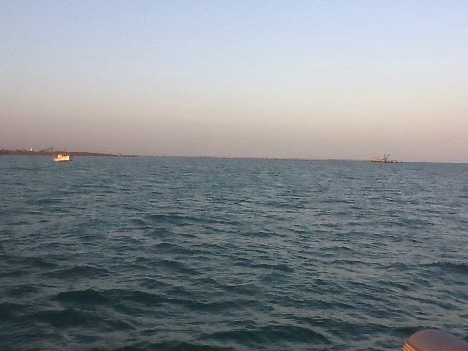
Too hazy for pictures of the marina at Puerto Valero which shows up on the chart at the point of the sand spit that looks like a deflated penis. Actually it is half a mile closer to shore than shown. The chart depiction is short by nearly half a mile which would have been a major disaster had we come in at night.
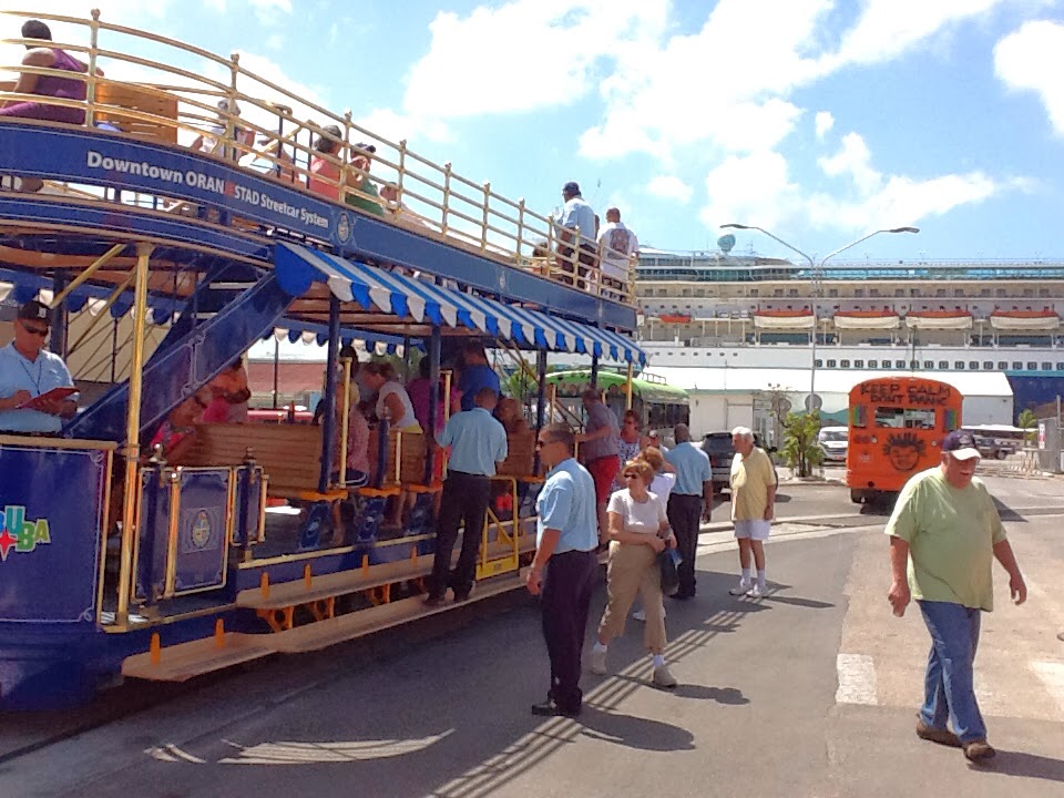
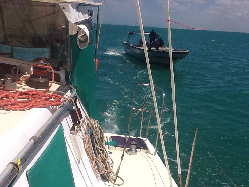
Good bye Puerto Valero where the Costagardia came aboard to check us out. Very little English and a newbee who wanted to see everything and then some: engine serial numbersxscdxwcscfy; second ID; etc. even had me sign the document he filled out in Espanol and print in my FL driver's license number. My US passport number wasn't enough!
Got a shower, drink, great enchilada dinner, and 9 hrs. rack time. Woke to clear ( again) skies and little wind. After bacon, egg, hash browns, and coffee, we raised the main, pulled up the anchor at around 0915 and headed WSW (248*) for San Blas some 30+ (we hope -) hours away. Winds and seas so far (it's barely 1000) are light at under 10 kts and 1'. By noon seas are up to 3-4' and winds are10-12 kts. OK motor sail 'cause we need to make the 262 nm trip in under 32 hours to arrive in the light. That means we have to maintain an average speed above 7.5 kts/hr.

If you are interested in AIS and autopilot read on. Otherwise skip the next two sections.

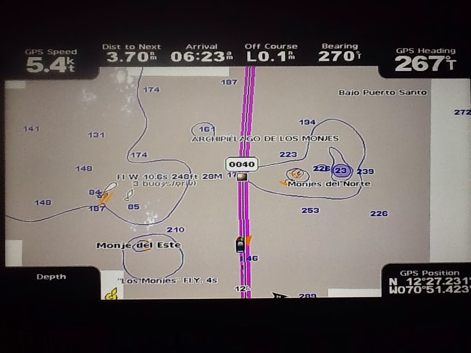
AIS, Automatic Identification System, is an international vessel identification system that transmits vessel information over the VHF radio band. It reaches out from the vessel about 30 miles. It gives other vessels who have receivers particulars about the vessel such as name, type of vessel, cargo, direction, speed, destinations, etc. All vessels 100 tones and over are required to have and use them. Vessels show up on our chart plotter as green triangles which when "clicked" on give us all this myriad of info including Closest Approach in miles and time. What a wonderful thing to have especially at night or when they are below our horizon (only approx. 7-8 miles away) and when they're multiple "targets".

Also see the targets in the left corner in Cartagena Harbour
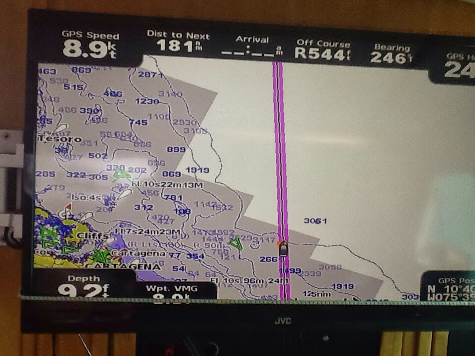
The autopilot is another helper that needs constant monitoring. When set to follow a course, it is constantly influenced by the wind (direction and strength) and currents. This is shown by the Off Course reading on the chart plotter as the bow swings left and right. One has to adjust it, seems like, every few minutes to get back within the 600' corridor on either side of the track where we like to be. Being off course on either side means a longer passage.

1600: The wind just gusted to 30 knots turning us into the wind. Sail boats do this as a safety measure: the stern is pushed around by the main overcoming the rudders. Given that the winds are expected to rise even further, we rolled up the jib snd turned fully into the wind and brought the main down while we crashed over the 10+' waves. It came down easily and folding nicely into the sail pack. I didn't get fully drenched, but wet enough pulling her down at the base of the mast. Back towards our course (we went off 0.6 nm off to the right (starboard and N)) and are still making good time: over 7.5 nm/hr average with just the jib back up.

0845, 2/22/2014: "Security, Security, Security! This is warship 04 at (position) preparing for live gunnery practice...." Oops...blundered into a firing range? After some consultation with warship 04 on the VHF we exchanged positions and an acknowledgement that they "saw" and "plotted" us 20 nm N of their position. They promised to try not to shell us given their course and aiming direction which should be behind us. Seas 5-7'; winds 11-14 knots abaft the beam; sunny with clouds; jib only 'till,after breakfast.

Most waves out here at the western end of the Caribbean Sea are doubles, a large wave followed in 4-6 seconds by another slightly smaller one. Both are followed by another big set 4 or 5 seconds later. This makes for a twisty, bumpy ride when combined with the wavelets that are created by the wind. Also, there is a cross wave pattern created by the currents (?) that juggles the whole thing into what a fellow cruiser called a "washing machine". For a catamaran with two hulls it's not so bad. But, for mono-maran, ouch. Things and people get a good tossing/bashing.

San Blas, Panama 30 hours after we left Puerto Valero. We managed to stay below the nasty weather just NNW of us which is there basically year round. It is supposed to be the World's third worst, on a par with Cape Horn. We did get a taste of it two nights ago, but here we skirted past. We did do it motor sailing to make it here in daylight having left Valero at around 0900. Simple, straight forward passage thru the reefs, hung a right then a left, and BINGO Nargana and Southern Comfort with Rob and Lauren blowing the horn celebrating our arrival.


Wednesday, February 19, 2014

Aloha, Aruba


Good bye to the dust and mud it creates. Good bye to the one way streets and the circles they create. Good bye to the green grass (I hope) growing on the sugar scoop steps. We're off... All the repairs that could be made have been. The auto pilot is holding, so far and we haven't run into anything.

The Oranjestad tram that runs from the cruise terminal to old town.

We left the Renaissance Marina at around 1230. We cast off the dock lines holding us to windward on another boat in the slip next door and pulled into the basin just in front of us with the engines. Linda pulled in the dock lines while I steered. Once we were in front of our neighbor, I put her ( that's Kuhela, not Linda) tin neutral, ran forward and pulled up the anchor. We turned into the wind and Linda, now at the helm, kept us going forward as the chain rolled in. Anchor's away, Linda turns us, and we head out the channel for Barcadera: up wind and wave (East). It's blowing 20+ and the seas crashing over the bow are 5-6 ft. Barcadera is where we have to come along side the commercial pier to go into Customs and Irritation to check out, captain only, no Commadores allowed. Takes about 20 minutes filling out papers that I did checking in (no copier, I guess) and we're released to our next port: Cartagena, Columbia.

From a women's point of view: Harry didn't mention that our neighbors in the Marina were over million dollar boats and 90 feet long. With the wind blowing 20 (great for sailing) it wasn't such an easy task getting out of the slip. Fortunately, we only came as close as about 4 feet. The big plus was having our Aruban mechanic (and now friend) helping us cast off the lines. And now, about customs - if you read the last blog you may remember I did not do so well climbing out of the dingy onto the dock. There were huge tires I had to climb with the waves crashing into the side of the dingy and I was slammed against the tires as the dingy flew out from under my feet . It wasn't a pretty sight. Picture a 65 year old hanging on and trying to pull herself up 5 feet over the tires onto the dock - not graceful!! So, after 4 weeks in Aruba, my rib cage has recovered and the pain is gone so you can imagine how I felt going again to customs. Oh, but of course, this time we would be on the boat and I could step onto the dock. HAH!!!! Too far to even jump, as I would have to hang onto the top set of tires and climb over. SO. I told Harry to tell them to come to me if they wanted to see me. Turns out they didn't even care.


We make our 1400 est. departure, haul up the main sail, turn starboard (left), and head out for the high seas. Not so high, thankfully, as we were lead to believe by the grib (wifi weather files) files: 1-3ft. seas and 10-16 knot winds. We sail down wind, wing and wing (that's the main out to starboard and the jib - that' the smaller sail at the bow - polled out to port. Dolphins follow us in our bow wave for a good half hour, breaking off when we pass two tankers transferring cargo right in the middle of our course (rumb line) for Bahia Honda, our first rest stop in Columbia. We'll stop there early tomorrow morning (looks like 0530 as we're making much better time than we planned: 6.9 v. 6 knots); or if we aren't pooped, continue on to Manaure another 58 nautical miles further on. We'll see tomorrow.

The sun is setting and we will arrive at some islets, Monjes del Este, at around 2200. Yah, after dark: lousy planning I'd say. I learned why my auto pilot, Mona, makes so much noise - from the start, even. Seems the bit.h had a leak in a hydraulic line or two. With my trusty, dusty little adjustable wrench, I gave her a tweak 'cause we had noticed that in addition to her moaning she was loosing fluid, not much, but some. Now she's quiet and keeping her fluid to her self. Oh, joy and rupture!

Dawn: COLUMBIA! Wow, how under impressive: flat, dersert-like Aruba-' few lights, one ship anchored at Badia de Portete probably to load coal from the largest open pit in South America (Columbia, anyway). Winds are under 10 with a following 2' sea. Definately unexpected and forecasted: winds 20-25, seas 6'+. Happy days are here again!

We bypassed Bahia Honda and re-routed for Manaure, important for its salt flats and propane fields. Woo-woo. We should get there at around 1500, drop sail, and anchor. It's a run of 160 nm and 25 hours. Pretty good we think for our first leg.

"What in the world do you do while underway? " you might ask. Fix things that break is number 1. As this is a boat in a very caustic environment, s..t happens with some regularity; maybe it's just another way to set the sails, like learning how to use the whisker pole: a telescoping pole attached to the mast that clips on to the in halyard and holds the jib out over the side keeping it from collapsing. Standing watches and looking for flotsam and other vessels; adjusting the course due to changes in wind direction and currents; keeping an eye on the depth sounder when we're in shallow (less than 50') waters, and a lot of reading both easy as well as educational (weather forecasting, storm tactics, cruising guides, etc.). And playing Spider and backgammon (Harry) on our computers which for Harry is an idiot player. Beats being a couch potatoe by just a little.

Manaure, Columbia is a salt shipment "pier" and conveyor/shoot off the beach. Nothing else but a few isolated houses. Arrived here, it's a lee shore, at 1500, put down the anchor, and that's it. No place to land even if we wanted to. What a terrible anchorage even for the fishermen who have to swim out to their boats morning and night. Winds were 20+ knots with a 2-3' chop bouncing us around most of the night.

Salt conveyor in background on a surprisingly calm morning after.


Manaure Playa (beach) with the fishing boats anchored off. This morning was clam with a light breeze which aided in putting the baton (a stiffening rod running fore and aft sewn into a pocket in the main) back in the main sail.

The best was yet to come.


The morning of the second day is warm with blue sky's, some puffy white coluds, wind 10-12 knots and virtually flat seas; like yesterday. We're off at 1100 heading for Bahia de el Rodadera some 120 nm further down the coast and just past Santa Marta. The headland just before Santa Marta has a reputation for some serious winds and seas. We'll be taking it very early in the morning tomorrow. Hopefully it's reputation will not survive the wee hours. I'm at the helm (driving, steering sorta) watching for Manaurian fishermen and dodging the two oil drilling (or maybe just pumping now) platforms named Chuchupa A & B some 17 mn ahead. We'll pass just left of them thru a restricted corridor which shows up on the chart as two, red dotted lines.

I can't believe I'm COLD! All afternoon while sitting at the helm with a 17-29 knot wind running over me and the thermometer showing 79* and I'm cold. Linda says she's cold, too, so I' apparently not coming down with anything. Wow: long pants and fleece jacket and definately in order.

It's 0140 on Wednesday the 19th, our second overnight passage. Linda has gone down below for a well deserved rest. We're off Cabo San Juan de Guie which is the beginning of the headland E of Santa Marta in the Tayrona National Part. This is the area noted for its huge seas and high winds that we are every apprehensive about. So far, knock on wood, following seas are 7-8' and winds are 17-20 knots off the shore to the port (S). We are running with only the main up trying to slow down so we don't get to our next anchorage, Bahia de el Rodadero, before dawn.

What a difference 2 hours and 14 nm makes: gusts to 41+ knots, seas to 10', and a wind shift. The boat was over powered and turned into the wind which it's supposed to do. Managed to get the sail down - thankfully the jib was already rolled on - and regained control with the engines. We were far enough off the coast that at least we didn't end up there. The short hop around Isla de Aguja saw us to calmer waters until we got past Santa Marta where the winds went back to 30+ knots. We turned around and beat a hasty retreat back to Santa Marta where we had to do circles for 2 hours before we got a port clearance to enter. We got fuel at the marina and had to check-in. Rob and Lauren lucked out bluffing their way thru without checking in. Here, not so.


Here's the Army dude that boarded us near Manaure. Very friendly with a smattering of English. Took pictures of everything even under my wall-hung tool chest?????


And his cutter...


Sunday, February 9, 2014

Holly Cow...Aruba, still

"Here we sit all broken hearted, paid to" fix "but only" paid, paid paid...

Making repairs in exotic places at exotic prices has taken on an almost new meaning. We are now into our 4th week here trying to get the steering fixed (we think it's done having put in a new helm pump) and the generator rebuilt after it injested sea water. The generator problem also came with a broken bearing in the raw water cooling pump which, of curse, needed to be replaced. Thankfully we were able to impose on Rob Dehaan's, Southers Comfort, Port Supply (wholesale branch of West Marine) account connection to purchase the pumps. FedEx shipped the first pump thru CuraƧao (apparently didn't know where Aruba is) taking a full week to get to us. The parts for the rebuild came in 4 days. Hopefully the new cooling pump will come a little faster now that they have some current, geographic experience.

So, here we sit on the downwind side of a semi-arid (too little sand inland to consider it a desert) island. Reminds we of living in Albuquerque, NM back in the 60's after I flunked out of Oregon State and before I joined the Army. Kuhela is covered in dust as we are: you wouldn't believe how brown a white wash cloth gets when you take a shower. In fact with the one or two short showers, and it mean SHORT, most of it is now mud. Sad, 'cause this really is an interesting place with sunny, warm temps (80's) tempered by the (damn) winds. People are very friendly and speak English better and more universally than in Puerto Rico. Lots of good restaurants at more reasonable prices than Orlando or Honolulu. By the way we changed our home port (printed over out engine hatches) to Honolulu and Hawaii from Monroe, NC. You should hear the comments from a constant flow of people passing by on the dock where we are Med-moored (anchor out front and backed in to nearly touching the dock) and tied off to the dock.

Yup, cruise ship, but only one, in the background. Usually there's two with another out of sight behind this one.


We went to the NW end of the island called Palm Beach where the hotels and condos are on the beach (as opposed to Eagle Beach where the high rise hotels and condos are behind the beach). We had Happy Hour drinks on the beach and then dinner (thrice) at some very good places. Yes, a good time was had by all...

We are toying with the idea of leaving here - yes it will happen - and heading straight for San Blas, Panama skipping Cartagena which we saw 18 years ago on a NCL cruise. But, after more research and a blog from Adina we have decided to hug the coast to Cartagena and then cross to San Blas. The wind and waves on a more direct route are not so good, especially off of Santa Marta with her gale force winds.